|
T
his
assignment is intended to provide a sense of the geographical contours
over which the history of Modern Britain unfolded. It will give
an appreciation of the topography, distances, cities, regions, and
political boundaries of England, Scotland, Wales, Ireland and the
various smaller islands that comprise Modern Britain. Students are
encouraged to use John Cannon (ed), Oxford Companion to British
History; S.J. Connolly, ed., Oxford Companion to Irish History;
Norman Davies, The Isles: A History as well as other atlases
and reference works.
You are not obligated to complete this assignment on your own. You
may collaborate with each other in preparing your maps (but beware
of shared errors). All items must be clearly labeled in block letters
on the maps (not number-keyed to a list in the margin) so that future
reference is easy for you and grading is easy for the instructor. Grades will
be based primarily on accuracy and neatness, but artistic flourish
and creativity will also be considered.
The blank maps supplied are the ones that must be used. Do not submit
computer-generated designs. Please staple the two maps together
and be sure to put your name on both pages.
Maps are due at the beginning of class on Monday, September 12.
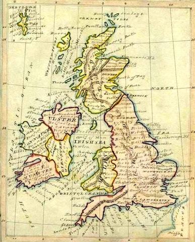
MAP I
In black ink draw borders for the following regions:
England
Wales/Cymru
| Ireland
Scotland (show Highlands and Lowlands)
|
Cities and towns
Aberdeen
Birmingham
Canterbury
Derry
Glasgow
Leeds
Manchester
Reading
Southampton
Wexford |
Bantry
Brighton
Cardiff
Dover
Liverpool
London
Oxford
Salisbury
Stirling
York |
Bath
Bristol
Cork
Dublin
Inverness
Norwich
Plymouth
Sheffield
St. Andrew's
|
Belfast
Cambridge
Culloden
Edinburgh
Hull
Newcastle upon Tyne
Portsmouth
Sheriffmuir
Swansea
|
|
MAP II
Counties and Provinces:
Cornwall
Durham
Lancashire
East Anglia
Ulster
|
Devon
Essex
Lincolnshire
Somerset
West Midlands
|
Cumbria
Hampshire
Northumberland
Suffolk
Yorkshire
|
Connaught/Connacht
Kent
Norfolk
Sussex
|
Rivers:
Boyne
Clyde
Humber
|
Liffey
Mersey
Severn
|
Thames
Tyne
|
Geographic Features:
Atlantic Ocean
English Channel
Isle of Man
North Sea
| Cambrian Mountains
Guernsey
Isle of Wight
Orkney Islands
| Irish Sea
Hebrides
Jersey
Shetland Islands
|
Greenwich Meridian (0° Longitude)
Loch Ness
Skye
|
|
|